2025
Seismic Lines Are Associated With Enhanced Ground Layer Evapotranspiration in Peatlands. M Bayatvarkeshi, S Ketcheson, P Korsah, M Schmidt, N Tabassum, et al. Ecohydrology 18 (6), e70102
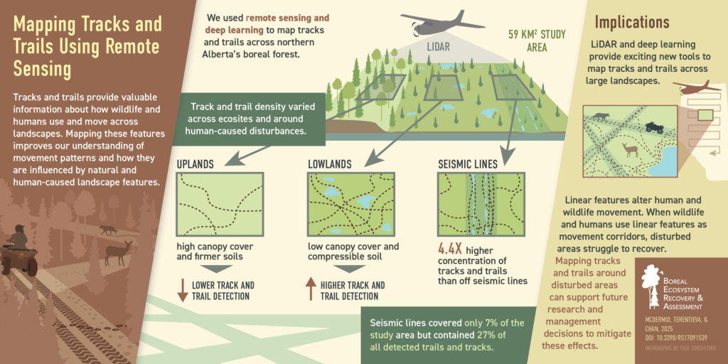
Mapping Trails and Tracks in the Boreal Forest Using LiDAR and Convolutional Neural Networks. GJ McDermid, I Terenteva, XY Chan. Remote Sensing 17 (9), 1539
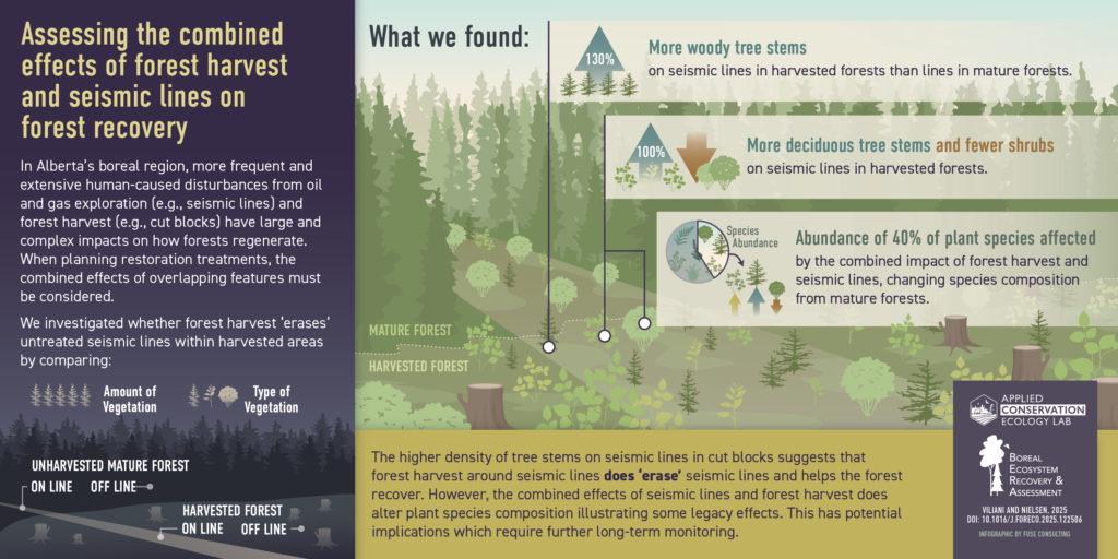
Composite effects of forest harvests and seismic lines influence re-establishment of trees and shrubs in Alberta’s mesic upland boreal forest. L Viliani, SE Nielsen. Forest Ecology and Management 580, 122506
2024
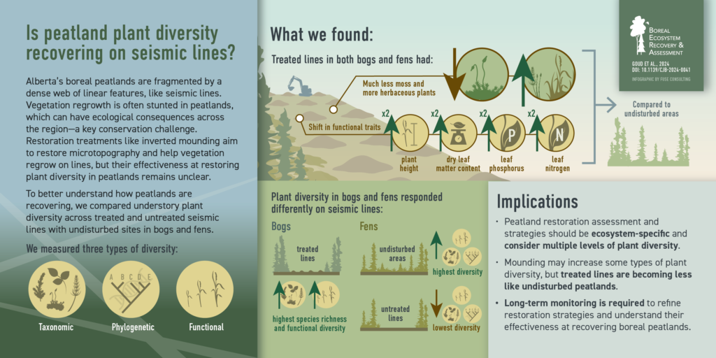
Do linear clearings in boreal peatlands recover? Comparing taxonomic, phylogenetic, and functional plant diversity. E. M. Goud, S. J. Davidson, A Dabros, K. Kleinke, M. A. Schmidt, and M. Strack. Botany. 16 October 2024
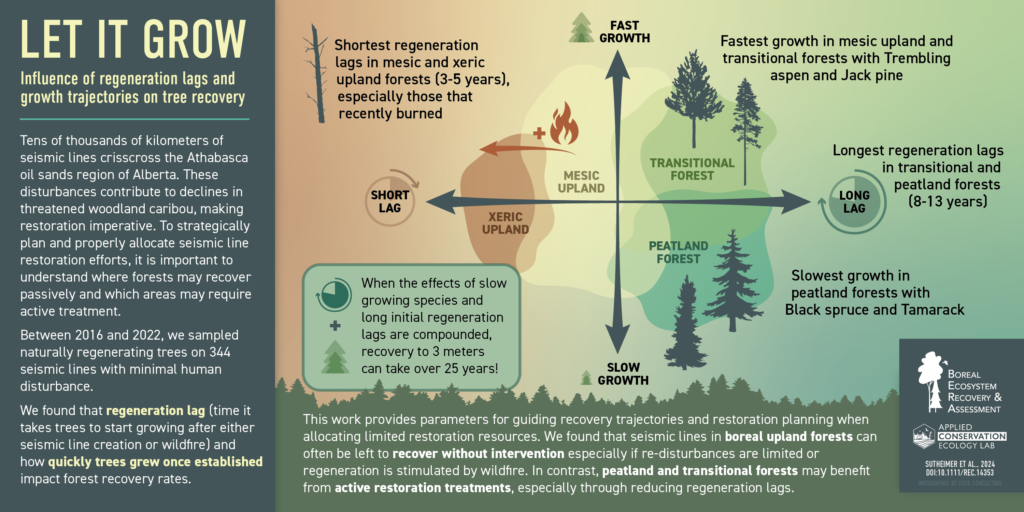
Regeneration lags and growth trajectories influence passive seismic line recovery in western North American boreal forests. CM Sutheimer, AT Filicetti, L Viliani, SE Nielsen. Restoration Ecology 33 (3), e14353
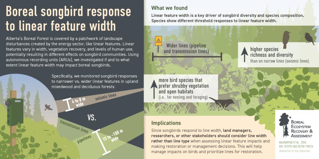
Response of boreal songbird communities to the width of linear features created by the energy sector in Alberta, Canada. T Kalukapuge, LFV Leston, JA Martínez-Lanfranco, E Bayne. Avian Conservation and Ecology 19 (2)
An initial assessment of winter microclimatic conditions in response to seismic line disturbance in a forested peatland. Bayatvarkeshi, M., Ketcheson, S., Weiland, L., & Strack, M. Hydrological Processes, 38(7), e15243.
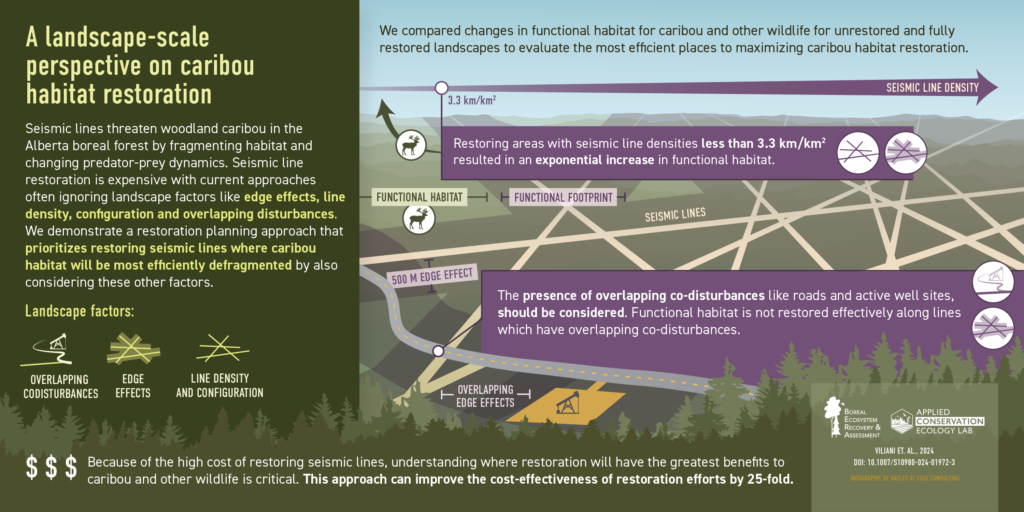
Identifying restoration priorities for habitat defragmentation: a case study in Alberta’s oil sands. L Viliani, CM Sutheimer, SE Nielsen. Landscape Ecology 39 (10), 178
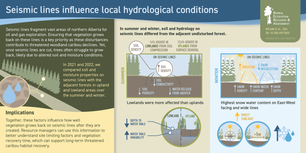
The influence of seismic lines on local hydrology and snow accumulation in the boreal region of northern Alberta. L Weiland, S Ketcheson, M Strack, GJ McDermid. Hydrological Processes 38 (12), e70032
Early Succession Across Boreal Forest Transitions After Linear Disturbance and Wildfire CM Sutheimer, SE Nielsen. Forests 16 (8), 1333
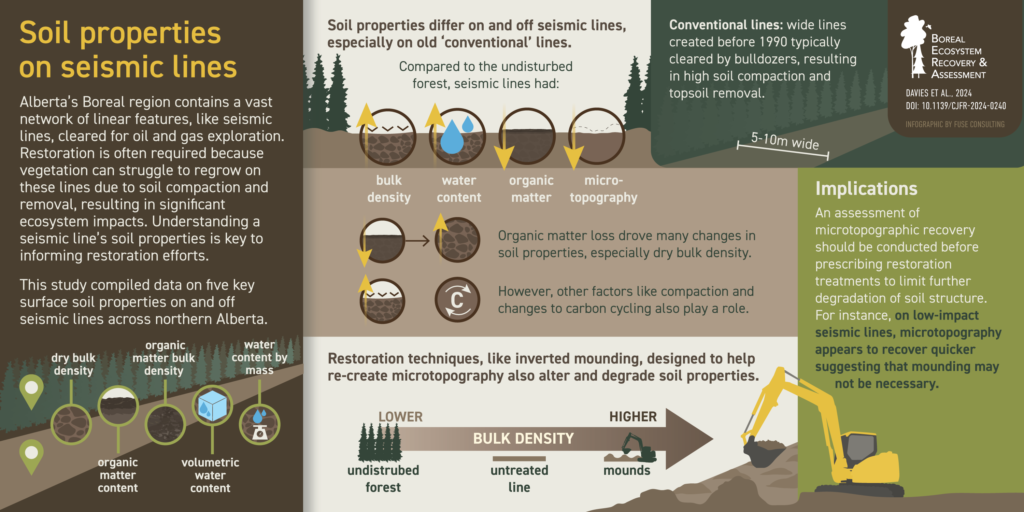
A data compilation and synthesis of the impacts of seismic surveys on surface soil properties in boreal Alberta, Canada. MA Davies, SJ Davidson, PJ Deane, A Filicetti, S Ketcheson, P Korsah, K Kleinke, S.E. Nielsen, N. Tazenbaum, J.M Waddington, L. Weiland, S. Wilkinson, and M. Strack. Canadian Journal of Forest Research 55, 1-18
2022
Jocelyn Gregoire, Richard Hedley, and Erin M. Bayne.
NV Sánchez, L Sandoval, RW Hedley, CC St Clair, EM Bayne
Frontiers in Ecology and Evolution, 198
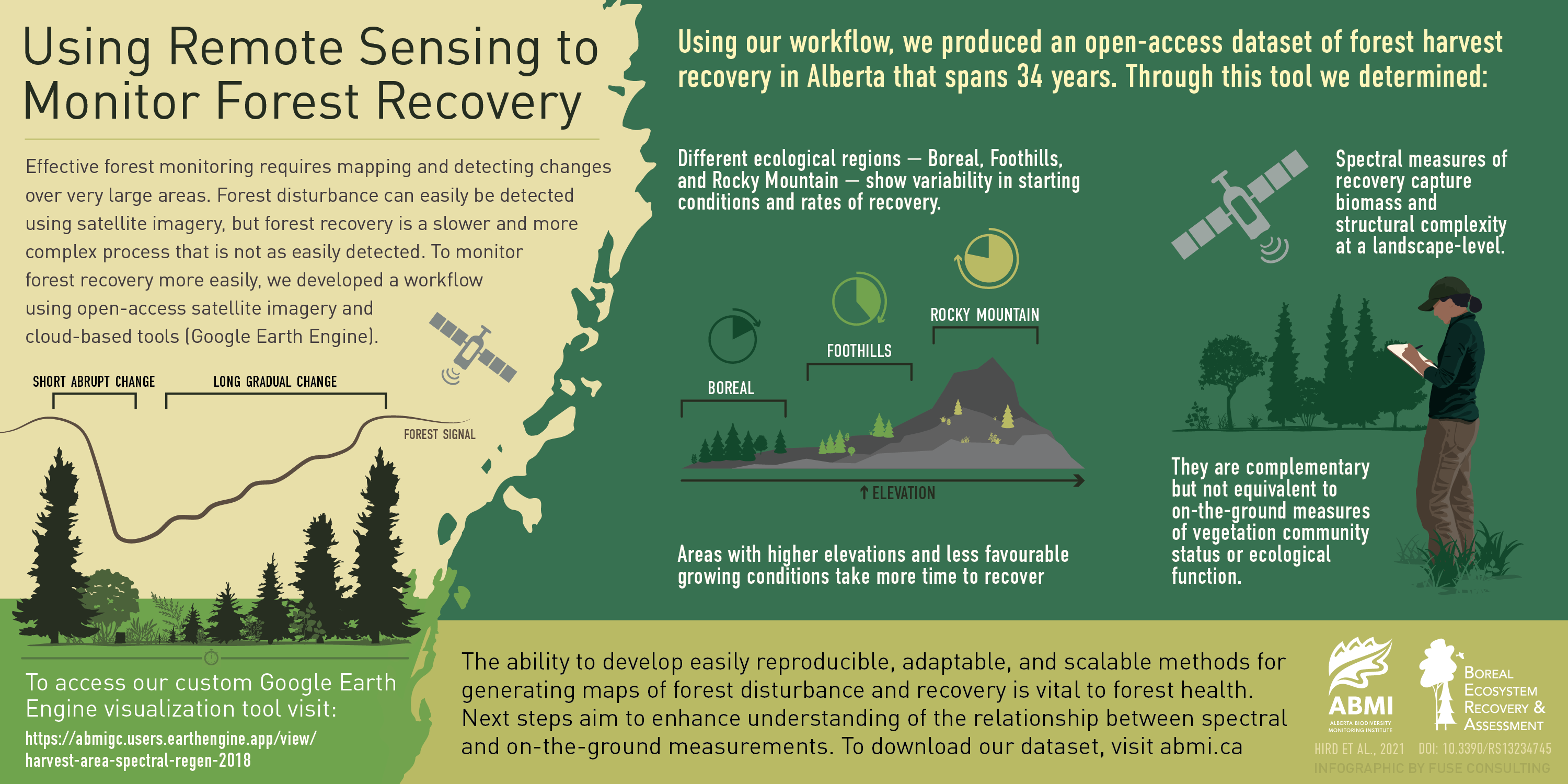
Satellite Time Series and Google Earth Engine Democratize the Process of Forest-Recovery Monitoring over Large Areas
JN Hird, J Kariyeva, GJ McDermid
Remote Sensing 13 (23), 4745
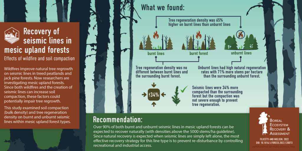
Effects of wildfire and soil compaction on recovery of narrow linear disturbances in upland mesic boreal forests
AT Filicetti, SE Nielsen
Forest Ecology and Management 510, 120073
2021
Effects of Fire Severity and Woody Debris on Tree Regeneration for Exploratory Well Pads in Jack Pine (Pinus banksiana) Forests
AT Filicetti, RA LaPointe, SE Nielsen
Forests 12 (10), 1330
Graminoids vary in functional traits, carbon dioxide and methane fluxes in a restored peatland: implications for modeling carbon storage
EM Goud, S Touchette, IB Strachan, M Strack
bioRxiv doi: https://doi.org/10.1101/2021.05.27.445980
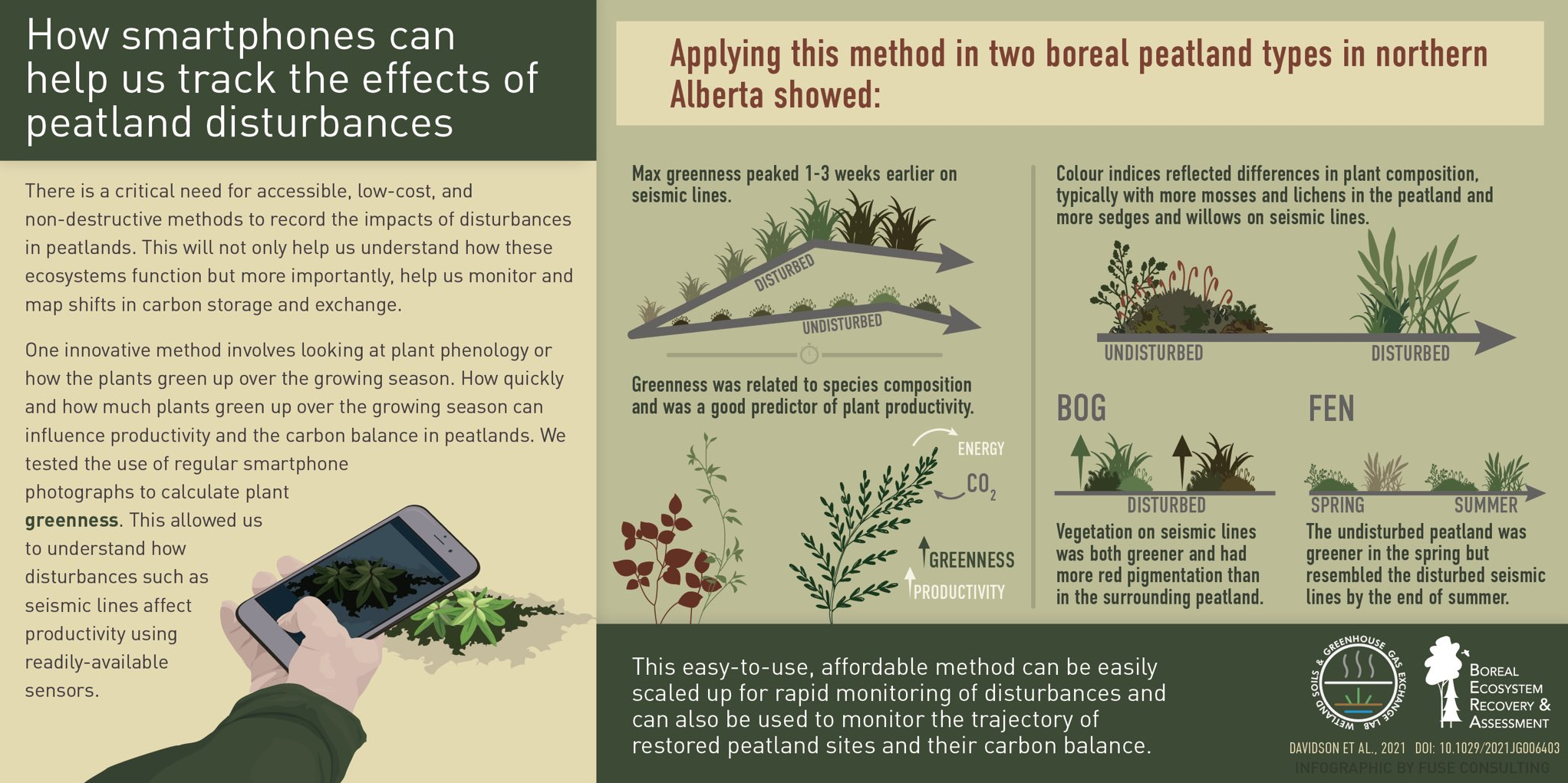
Linear disturbances shift boreal peatland plant communities toward earlier peak greenness
SJ Davidson, EM Goud, A Malhotra, CO Estey, P Korsah, M Strack
Earth and Space Science Open Archive ESSOAr
 Distance truncation via sound level for bioacoustic surveys in patchy habitat
RW Hedley, SJ Wilson, DA Yip, K Li, EM Bayne
Bioacoustics 30 (3), 303-323
ER DeLancey, B Brisco, LJT McLeod, R Hedley, EM Bayne, K Murnaghan, …
Water 13 (17), 2327
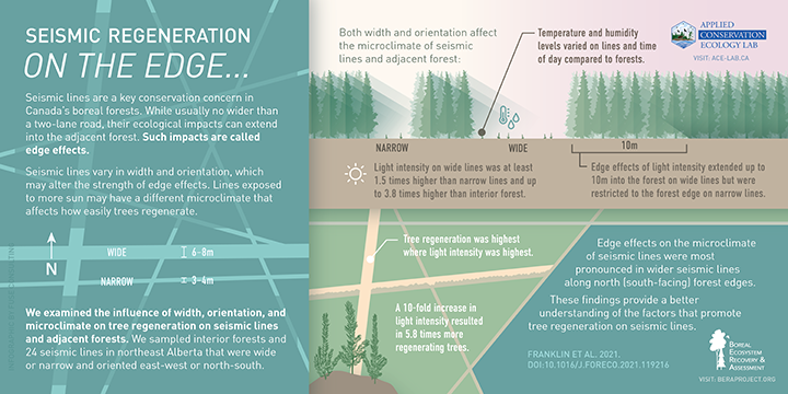
CMA Franklin, AT Filicetti, SE Nielsen
Forest Ecology and Management 492 (2021) 119216
2020
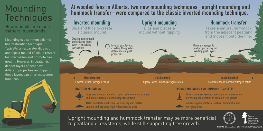
Disturbing to restore? Effects of mounding on understory communities on seismic lines in treed peatlands
LFI Echiverri, SE Macdonald, SE Nielsen
Canadian Journal of Forest Research 50 (12), 1340-1351 1 2020
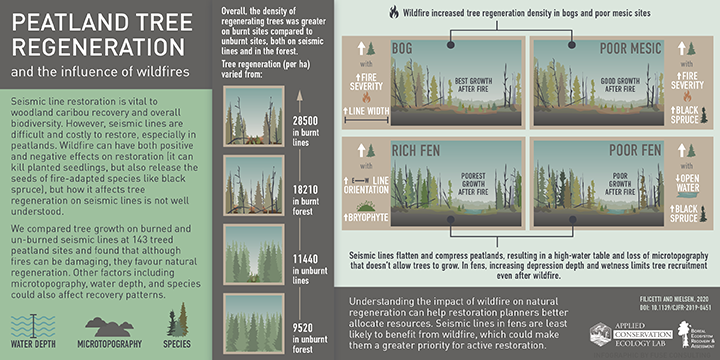
Tree regeneration on industrial linear disturbances in treed peatlands is hastened by wildfire and delayed by loss of microtopography
AT Filicetti, SE Nielsen
Canadian Journal of Forest Research 50 (9), 936-945 4 2020
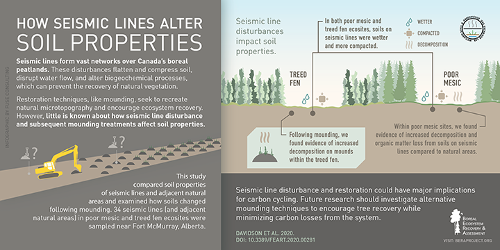
Seismic line disturbance alters soil physical and chemical properties across boreal forest and peatland soils
SJ Davidson, EM Goud, C Franklin, SE Nielsen, M Strack
Frontiers in Earth Science 8, 281
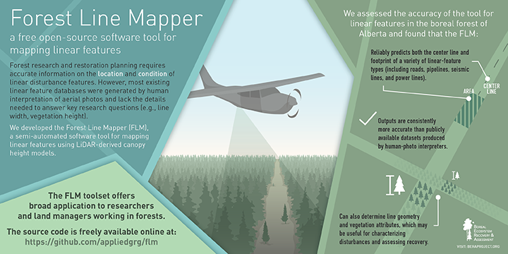
The Forest Line Mapper: A Semi-Automated Tool for Mapping Linear Disturbances in Forests
GL Queiroz, GJ McDermid, MM Rahman, J Linke
Remote Sensing 12 (24), 4176
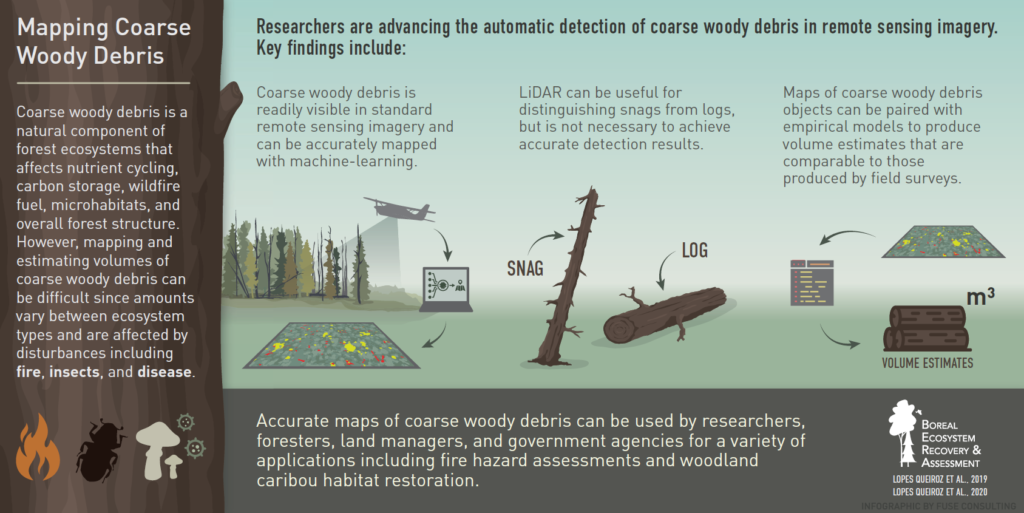
Estimating Coarse Woody Debris Volume Using Image Analysis and Multispectral LiDAR
GL Queiroz, GJ McDermid, J Linke, C Hopkinson, J Kariyeva
Forests 11 (2), 141
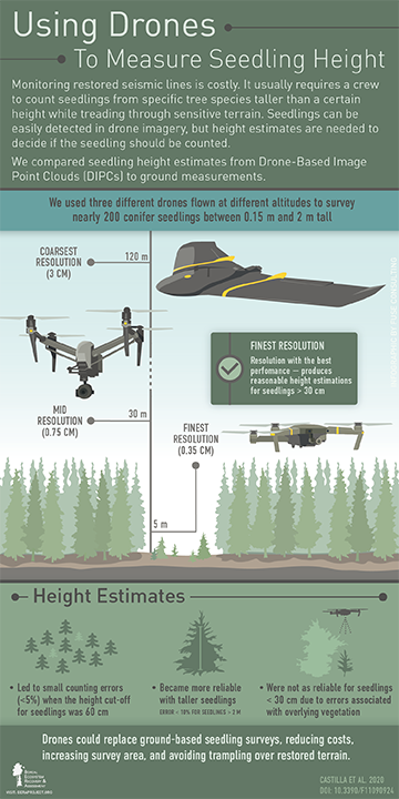
G Castilla, M Filiatrault, GJ McDermid, M Gartrell
Forests 11 (9), 924
Use of an unmanned aerial vehicle and sound localization to determine bird microhabitat
SJ Wilson, RW Hedley, MM Rahman, EM Bayne
Journal of Unmanned Vehicle Systems, 1-8
Modeling the occurrence of the Yellow Rail (Coturnicops noveboracensis) in the context of ongoing resource development in the oil sands region of Alberta
R Hedley, L McLeod, D Yip, D Farr, P Knaga, K Drake, E Bayne
Avian Conservation and Ecology 15 (1)
Distance truncation via sound level for bioacoustic surveys in patchy habitat
RW Hedley, SJ Wilson, DA Yip, K Li, EM Bayne
Bioacoustics, 1-21 1 2020
2019
Caribou conservation: restoring trees on seismic lines in Alberta, Canada
AT Filicetti, M Cody, SE Nielsen
Forests 10 (2), 185 10 2019
High precision altimeter demonstrates simplification and depression of microtopography on seismic lines in treed peatlands
CJ Stevenson, AT Filicetti, SE Nielsen
Forests 10 (4), 295 5 2019
Comparison of LiDAR and digital aerial photogrammetry for characterizing canopy openings in the Boreal Forest of Northern Alberta
A Dietmaier, GJ McDermid, MM Rahman, J Linke, R Ludwig
Remote Sensing 11 (16), 1919
Automated detection of conifer seedlings in drone imagery using convolutional neural networks
M Fromm, M Schubert, G Castilla, J Linke, G McDermid
Remote Sensing 11 (21), 2585
Mapping coarse woody debris with random forest classification of centimetric aerial imagery
G Lopes Queiroz, GJ McDermid, G Castilla, J Linke, MM Rahman
Forests 10 (6), 471
Petroleum exploration increases methane emissions from northern peatlands
M Strack, S Hayne, J Lovitt, GJ McDermid, MM Rahman, S Saraswati, …
Nature communications 10 (1), 1-8
Songbird community response to regeneration of reclaimed wellsites in the boreal forest of Alberta
SJ Wilson, EM Bayne
Journal of Ecoacoustics 3, 1-11 4 2019
2018
Fire and forest recovery on seismic lines in sandy upland jack pine (Pinus banksiana) forests
AT Filicetti, SE Nielsen
Forest Ecology and Management 16 2018
UAV Remote Sensing Can Reveal the Effects of Low‐Impact Seismic Lines on Surface Morphology, Hydrology and Methane (CH4) Release in a Boreal Treed Bog
J Lovitt, M Rahman, S Saraswati, GJ McDermid, M Strack, B Xu
Journal of Geophysical Research: Biogeosciences
Detection of Coniferous Seedlings in UAV Imagery
C Feduck, J McDermid, Gregory, G Castilla
Forests 9 (7), 432
Sound localization for estimating population densities of birds: Progress, challenges, and opportunities
RW Hedley, EM Bayne
The Journal of the Acoustical Society of America 144 (3), 1849-1849 2018
Use of an acoustic location system to understand how presence of conspecifics and canopy cover influence Ovenbird (Seiurus aurocapilla) space use near reclaimed wellsites in the boreal forest of Alberta
S Wilson, E Bayne
Avian Conservation and Ecology 13 (2)
Deciduous tree species classification using object-based analysis and machine learning with unmanned aerial vehicle multispectral data
SE Franklin, OS Ahmed
International Journal of Remote Sensing 39 (15-16), 5236-5245 66 2018
Pixel-and object-based multispectral classification of forest tree species from small unmanned aerial vehicles
SE Franklin
Journal of Unmanned Vehicle Systems 6 (4), 195-211
Detection accuracy of new well sites using Landsat time series data: a case study in the Alberta Oil Sands Region
RJ Wasson, SE Franklin
Remote Sensing Letters 9 (2), 160-169 1 2018
2017
Effects of linear disturbances and fire severity on velvet leaf blueberry abundance, vigor, and berry production in recently burned jack pine forests
CA Dawe, AT Filicetti, SE Nielsen
Forests 8 (10), 398 10 2017
Use of unmanned aerial vehicles for monitoring recovery of forest vegetation on petroleum well sites
JN Hird, A Montaghi, GJ McDermid, J Kariyeva, BJ Moorman, SE Nielsen, …
Remote Sensing 9 (5), 413
Measuring vegetation height in linear disturbances in the boreal forest with UAV photogrammetry
S Chen, GJ McDermid, G Castilla, J Linke
Remote sensing 9 (12), 1257
Google earth engine, open-access satellite data, and machine learning in support of large-area probabilistic wetland mapping
JN Hird, ER DeLancey, GJ McDermid, J Kariyeva
Remote sensing 9 (12), 1315
Northern conifer forest species classification using multispectral data acquired from an unmanned aerial vehicle
SE Franklin, OS Ahmed, G Williams
Photogrammetric Engineering & Remote Sensing 83 (7), 501-507 22 2017
Hierarchical land cover and vegetation classification using multispectral data acquired from an unmanned aerial vehicle
OS Ahmed, A Shemrock, D Chabot, C Dillon, G Williams, R Wasson, …
International journal of remote sensing 38 (8-10), 2037-2052 75 2017
Object-based wetland characterization using radarsat-2 quad-polarimetric SAR data, landsat-8 OLI imagery, and airborne lidar-derived geomorphometric variables
SE Franklin, OS Ahmed
Photogrammetric Engineering & Remote Sensing 83 (1), 27-36 22 2017
