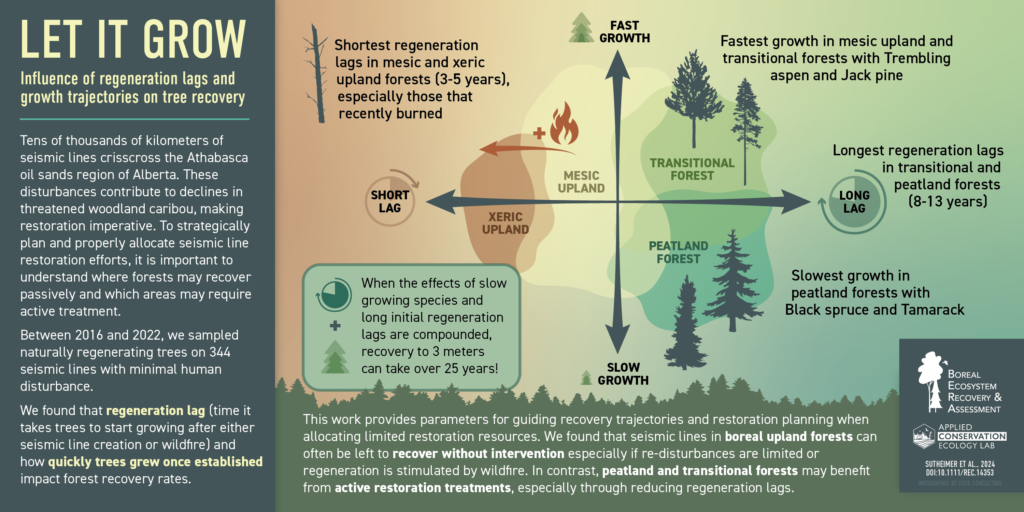
Seismic-Line Regeneration Lags Vary Strongly Across Ecosite Types. Understanding these Patterns is Part of the Key to Effective Restoration Planning
Seismic lines recover slowly, especially in peatlands and transitional forests. Using data from 344 lines, BERA researchers have shown that these wetter ecosystems have long regeneration lags (8–13 years) and slow-growing trees, pushing recovery times past 30 years. Upland lines recover faster—often within 15–20 years—because lags are shorter and species grow quicker, especially where wildfire has reset conditions. All peatland and transitional lines observed in this work showed long delays, while many upland lines did not. Active restoration should focus on sites where it can meaningfully shorten these long lags.
Read the full paper here.
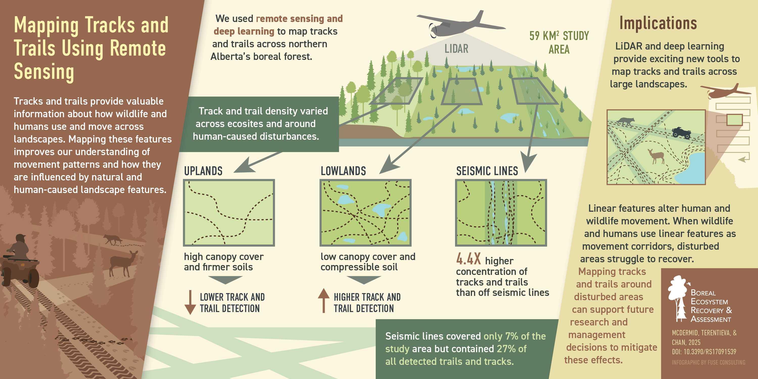
Trails and Tracks Can Be Mapped Operationally Over Large Areas Using LiDAR
Forest Harvest Areas Partially “Erase” Seismic Line Disturbances
Forest harvest operations can increase tree regeneration, reducing the effects of prior disturbances. BERA researchers found that seismic lines inside harvested areas had far more young trees — especially deciduous species — and fewer shrubs than untreated lines in mature forests. However, overlapping disturbances also create a unique species mix. Forest harvest can help restore forest structure on seismic lines, but it leaves a distinct combined legacy that may shape long-term forest composition.
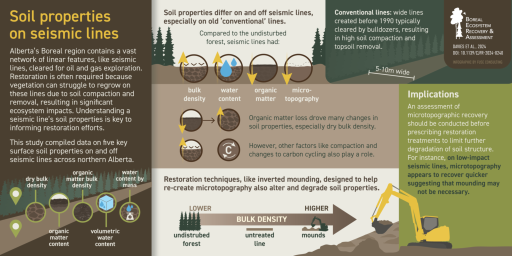
Understanding Soils is Part of the Key to Successful Seismic Line Restoration
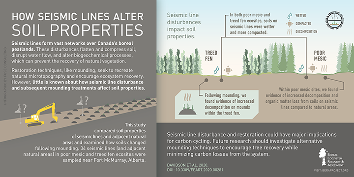
Seismic lines leave long-lasting influence on soil properties in northern Alberta. Compared to nearby forest, they have denser, more compacted soil, less organic matter, and flattened microtopography. This is especially true on older ‘legacy’ seismic lines. Some restoration treatments can inadvertently make these problems worse. Checking whether microtopography has recovered is essential before considering restoration-treatment options.
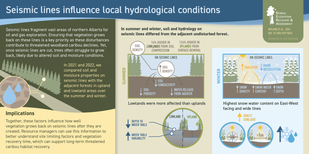
Seismic Lines Alter Local Hydrology and Patterns of Snow Accumulation
Seismic lines change soil and water conditions in ways that slow vegetation recovery. They make soils denser, reduce how easily water moves through them, and create more variable water tables. Snow also piles up more on wide, east–west lines. These shifts in hydrology help explain why seedlings struggle on seismic lines and point to factors that need to be considered in restoration planning.
Read the full article here.
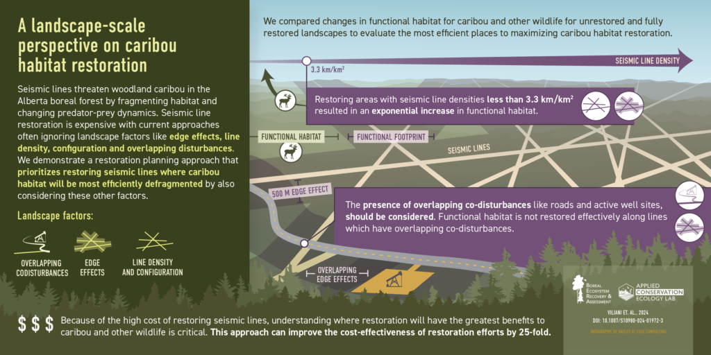
Landscape-scale Considerations Can Greatly Improve Restoration Efficiency
Restoring seismic lines alone won’t fully address the habitat-fragmentation issues troubling woodland caribou, since other disturbance footprints also exist on the landscape. BERA researchers have shown how considering the composition and configuration of multiple disturbances across the landscape can greatly increase the effectiveness of caribou-habitat restoration efforts.
Read the full paper here.
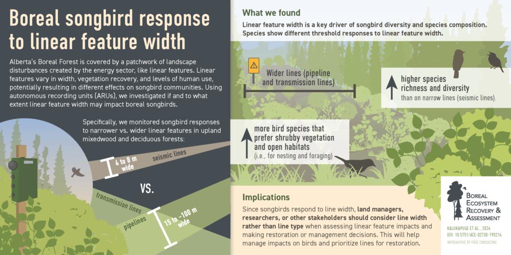
The Width of Linear Features is a Key Factor Influencing Songbird Effects
BERA research has shown that wider linear features, like pipelines and transmission lines, support more bird species and a different mix of species than narrow linear features like seismic lines. Broader corridors attract early-seral and shrub-loving birds, while narrower lines do not. Many species show clear threshold responses to width. Linear feature width is a key factor shaping songbird communities and needs to be included in management and regulatory models.
Read the full paper here.
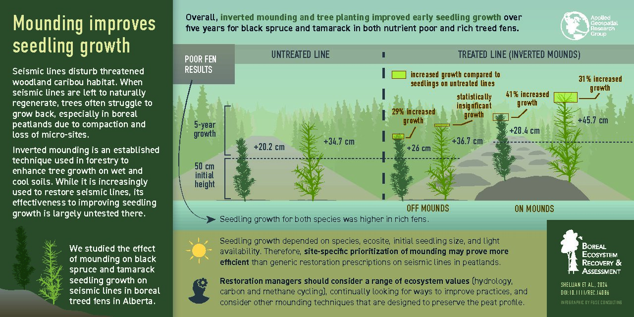
Silvicultural Treatments Hasten Seedling Growth in Boreal Treed Fens
Seismic lines in western Canada’s boreal region are linear disturbances that affect the habitat of threatened woodland caribou (Rangifer tarandus caribou). To hasten the return of forest cover and ultimately to restore caribou habitat, restoration managers use silviculture treatments in wet areas that involve the mechanical mounding of seismic lines to create artificial hummocks. Tree planting then takes place on top of these hummocks. However, the effectiveness of this silviculture technique for restoring seismic lines in peatlands is largely untested.
BERA researchers sampled incremental height growth of coniferous seedlings at 41 seismic line plots in poor and rich treed fens in northeast Alberta, Canada. They compared lines that had been treated with inverted mounding (a type of mechanical mounding) and subsequent tree planting, to nearby lines that were left untreated for natural recovery. Overall, they found that mounding and tree planting improved seedling growth compared to seismic lines regenerating naturally. However, growth responses were found to vary by species, ecosite, initial seedling size, and light availability.
For the full article click here.
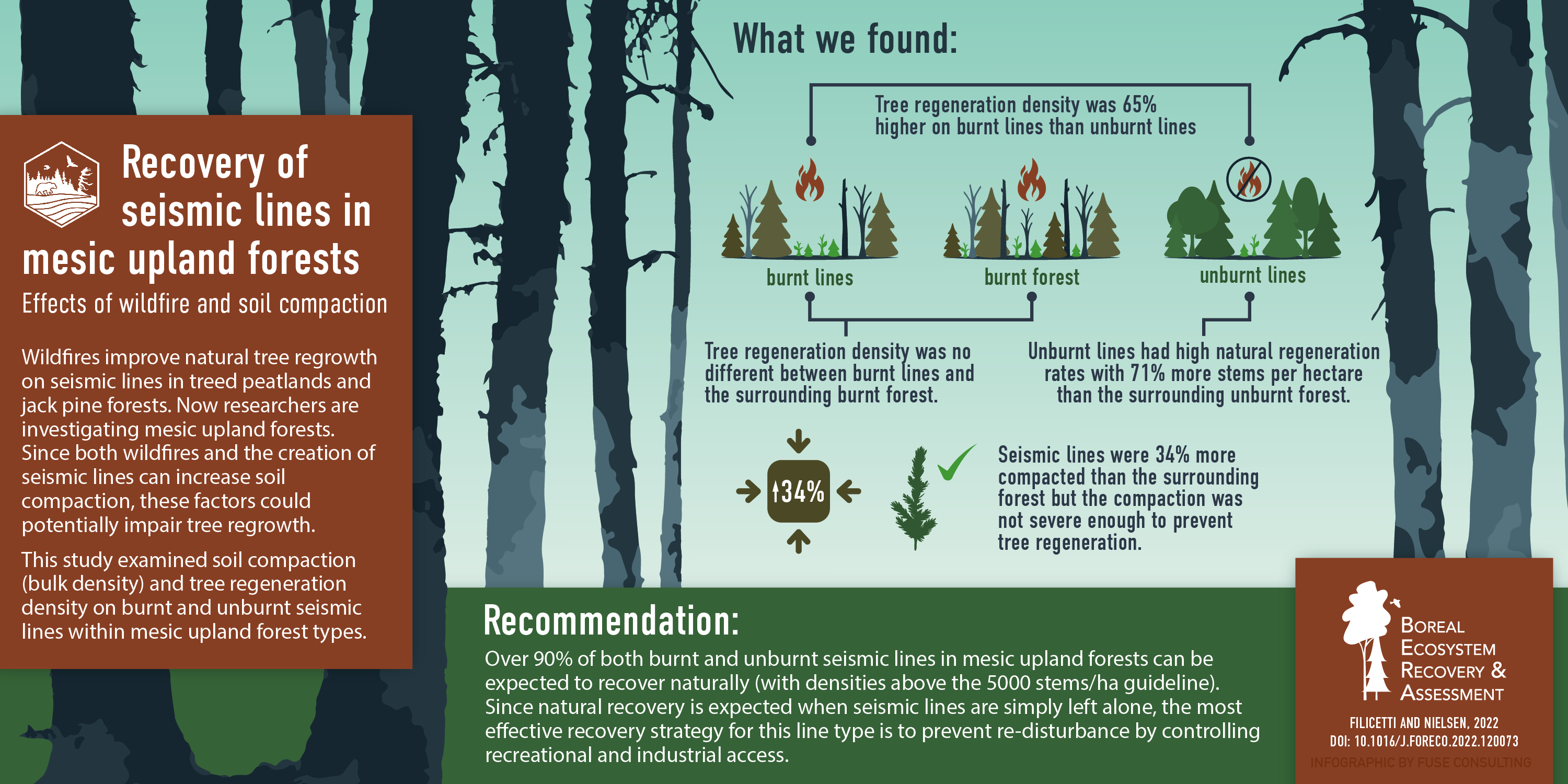
Most Lines in Mesic Uplands Can be Left for Natural
Alberta’s legacy seismic lines need restoration actions, but the sheer volume of lines on the landscape is daunting. Part of the challenge involves distinguishing lines that require active treatments from those that can be left for natural. Wildfires are the dominant disturbance agent in the boreal forest and can be an effective promoter of natural restoration in the right situations.
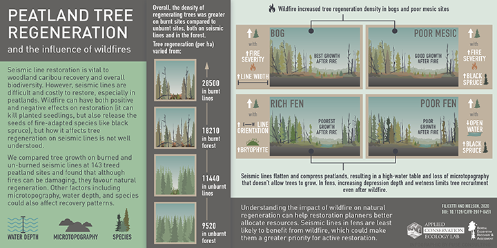
BERA researchers have previously published on the topic of wildfire effects on natural tree growth in jack pine forests and treed peatlands. Here, they tackle mesic upland forests. The work shows that tree regeneration density is 65% higher on burnt lines than unburnt lines in this ecosite type, and that fires can effectively “erase” lines from the surrounding matrix. However, even unburnt lines in the study had high rates of natural regeneration. This suggests that most lines in mesic upland forests can be effectively left for natural. These findings could help prioritize limited restoration dollars to more challenging ecosite types.
For the full article click here.